Bali Is Closer Than You Think — Here Is Exactly Where It Sits
Most people hear “Bali” and picture the photos — rice terraces, temple gates, turquoise water. But when it comes to answering where is Bali on a map, many travelers draw a blank. That missing knowledge costs you time in planning, money in booking wrong routes, and clarity in understanding what kind of destination this actually is.
Bali is a real, specific island with precise coordinates, a clear country, and a geography that shapes everything from its climate to its culture. Know where it is, and every other travel decision gets sharper and easier.
Where Is Bali? The Direct Geographic Answer
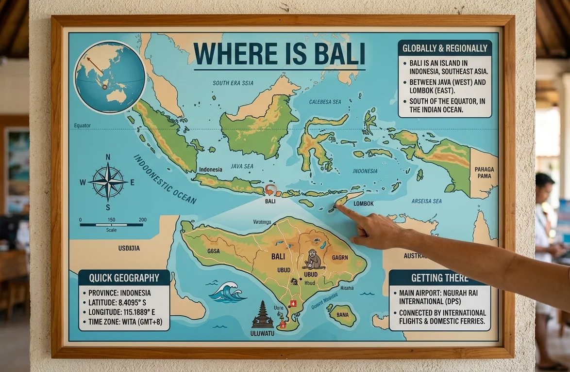
Bali is an island in Indonesia, located in Southeast Asia. It sits between the islands of Java to the west and Lombok to the east. Geographically, Bali lies at approximately 8°S latitude and 115°E longitude, placing it just south of the equator.
The island belongs to the Lesser Sunda Islands chain, which stretches east from Java across the Indonesian archipelago. Bali is one of Indonesia’s 17,000+ islands but stands as its most internationally recognized destination.
Key geographic facts at a glance:
| Detail | Information |
|---|---|
| Country | Indonesia |
| Region | Southeast Asia |
| Island Group | Lesser Sunda Islands |
| Coordinates | 8.3405° S, 115.0920° E |
| Area | 5,780 km² (2,232 sq mi) |
| Capital City | Denpasar |
| Nearest Major Neighbor | Java (west), Lombok (east) |
| Time Zone | WITA — Central Indonesia Time (UTC+8) |
| Population | ~4.3 million people |
| Official Language | Indonesian (Bahasa Indonesia) |
Which Country Does Bali Belong To?
Bali is part of Indonesia, the world’s largest archipelago nation. Indonesia is a sovereign republic with Jakarta as its national capital. Bali itself is one of Indonesia’s 38 provinces, carrying the official name Bali Province.
Many first-time visitors assume Bali operates as its own country because its identity feels so distinct — its own religion, language dialect, artistic traditions, and tourism economy. That distinctiveness is real, but politically and legally, Bali sits under Indonesian governance, uses the Indonesian Rupiah (IDR), and operates under Indonesian law.
The distinction matters practically. Your visa is an Indonesian visa. Your currency exchange deals in Indonesian Rupiah. Your emergency contact is the Indonesian consular system. Knowing that Bali sits within Indonesia — not beside it — helps you prepare correctly.
Where Is Bali on the World Map? Understanding Its Regional Position
Picture Southeast Asia. Draw a line south from Vietnam and Thailand, then continue southwest past the Philippines. You arrive at the Indonesian archipelago — a sweeping arc of islands running from Sumatra in the northwest all the way past Timor in the southeast.
Bali sits roughly in the center of that arc, just east of Java. This position makes it:
- 8 degrees south of the equator, giving it a tropical climate year-round
- Within 2.5 hours of Singapore by air, making it a natural regional hub
- Roughly 9–14 flying hours from Europe, depending on routing
- 6 hours from Australia’s east coast — explaining the massive Australian tourism presence
- 17+ hours from the US East Coast, typically with at least one connection
Its equatorial proximity means Bali experiences two seasons — wet and dry — rather than four. Temperatures stay between 24°C and 33°C (75°F–91°F) throughout the year, with humidity varying by season and elevation.
How Far Is Bali from Major Global Cities?
Distance shapes how accessible Bali feels to different traveler markets. Here is a full reference table:
| Departure City | Approximate Flying Distance | Typical Flight Time | Direct Flights? |
|---|---|---|---|
| Singapore | 1,660 km | ~2.5 hrs | Yes |
| Kuala Lumpur | 1,850 km | ~3 hrs | Yes |
| Sydney, Australia | 4,850 km | ~6.5 hrs | Yes |
| Dubai, UAE | 6,400 km | ~9 hrs | Yes |
| London, UK | 11,800 km | ~14–15 hrs | Yes (select carriers) |
| Paris, France | 12,000 km | ~15 hrs | Via connection |
| New York, USA | 16,300 km | ~20–22 hrs | Via connection |
| Los Angeles, USA | 14,200 km | ~17–19 hrs | Via connection |
| Tokyo, Japan | 5,100 km | ~7 hrs | Yes |
| Mumbai, India | 5,500 km | ~8 hrs | Yes |
Source: Distance data based on great-circle routes via IATA reference tables.
How Do You Get to Bali? Entry Points and Transport Options
Every major international arrival into Bali comes through one gateway: Ngurah Rai International Airport (DPS), located near Denpasar in the south of the island. The airport sits roughly 13 km from the Kuta-Seminyak tourist corridor and about 30 km from the cultural hub of Ubud.
By air:
- Direct flights connect Bali to over 40 international destinations
- Major carriers include Garuda Indonesia, Singapore Airlines, AirAsia, Qantas, Cathay Pacific, and Emirates
- Low-cost Asian carriers make Bali highly accessible from Singapore, Kuala Lumpur, Bangkok, and Hong Kong
Overland and sea routes:
- Travelers coming from Java can cross via the Gilimanuk ferry terminal, a short 30–45 minute boat ride across the Bali Strait
- Fast boats connect Bali to Lombok (east) and the Gili Islands in roughly 1.5–2 hours
- Cruise ships dock at the Benoa Harbour near Denpasar
Once on the island, transportation options include ride-hailing apps (Gojek and Grab operate widely), private car charters, scooter rentals, and taxi services. Bali has no public railway system.
Where Is Bali Located Within the Island Itself? Key Regions Explained
Knowing where is Bali on the global map is the first step. But the island itself covers 5,780 km² and holds dramatically different experiences across its regions. Here is a practical breakdown:
| Region | Location on Island | Known For | Best For |
|---|---|---|---|
| Kuta / Legian | South coast | Surf, nightlife, budget stays | First-time visitors, surfers |
| Seminyak | South, just north of Kuta | Luxury resorts, beach clubs | Upscale travelers |
| Ubud | Central hills | Rice terraces, temples, arts | Culture seekers, wellness travelers |
| Canggu | Southwest coast | Cafes, digital nomads, surf | Long-stay travelers, creatives |
| Nusa Dua | Southern peninsula | Resort hotels, calm water | Families, honeymooners |
| Uluwatu | Southern cliff tips | Dramatic surf, temple views | Surfers, architecture enthusiasts |
| Lovina | North coast | Dolphin watching, quieter pace | Off-the-beaten-path travelers |
| Sidemen | East foothills | Traditional village life | Trekkers, off-grid travelers |
| Amed | East coast | Snorkeling, diving, Japanese shipwreck | Divers, budget travelers |
What Time Zone Is Bali In?
Bali operates on WITA — Waktu Indonesia Tengah, or Central Indonesia Time. This places Bali at UTC+8, the same offset as Singapore, Hong Kong, and Perth (Western Australia).
This time zone detail carries real practical value:
- A traveler flying from London faces an 8-hour time difference (7 hours during British Summer Time)
- Travelers from Sydney face a 1-hour difference in standard time
- New York travelers deal with a 12–13 hour gap depending on daylight saving
Bali does not observe daylight saving time. Its time offset remains fixed at UTC+8 throughout the year, making scheduling calls with home easier to track.
What Is Bali’s Climate and How Does Its Location Shape the Weather?
Because where is Bali sits just 8 degrees south of the equator, the island gets consistent tropical warmth year-round. Elevation creates the key internal variation — coastal areas stay hot and humid, while highland zones like Ubud and Kintamani run noticeably cooler.
Bali’s two seasons:
- Dry Season (April–October): Lower humidity, less rain, brilliant sunshine. This is peak tourist season. July and August draw the largest crowds.
- Wet Season (November–March): Afternoon rain bursts are common, though mornings often stay clear. The jungle turns intensely green. Fewer tourists, lower prices.
Average temperatures by region:
| Area | Elevation | Average Temp (Dry) | Average Temp (Wet) |
|---|---|---|---|
| Kuta / Seminyak | Sea level | 30–33°C | 27–30°C |
| Ubud | ~300 m | 26–29°C | 23–27°C |
| Kintamani | ~1,500 m | 18–22°C | 15–19°C |
The best time to visit depends on your priorities. Dry season gives you postcard skies. Wet season gives you budget prices, lush landscapes, and fewer tourists at the temples.
Why Does Bali’s Location Make It Such a Powerful Travel Destination?
Geography explains a lot of Bali’s appeal. Its position within Southeast Asia creates an almost perfect convergence of natural and cultural factors:
- Volcanic soil from the island’s central volcanoes (including Mount Agung at 3,142 m) produces extraordinary agricultural fertility — those iconic rice terraces are a direct result of the island’s terrain
- Coral reef ecosystems along the east and northwest coasts create world-class dive and snorkel sites
- Equatorial sunlight supports year-round tourism, unlike temperate destinations with strict seasonal windows
- Regional hub position makes Bali an easy stopover or base for exploring wider Southeast Asia — Lombok, the Gili Islands, Java’s Yogyakarta, and Komodo National Park all sit within a short journey
Bali’s location also feeds its spiritual identity. The island’s Hindu Balinese population — rare in a predominantly Muslim Indonesia — developed in partial geographic isolation, producing a unique ceremonial and artistic culture that visitors experience directly.
Bali vs. Nearby Islands: How Does Its Location Compare?
Travelers frequently ask how Bali compares to its neighbors. Location shapes each island’s character differently:
| Island | Country | Distance from Bali | Character | Best For |
|---|---|---|---|---|
| Lombok | Indonesia | ~35 km east | More rugged, quieter | Trekkers, off-grid seekers |
| Gili Islands | Indonesia | ~80 km east | Tiny, car-free, beach-focused | Snorkelers, divers, couples |
| Java | Indonesia | ~3 km west (Gilimanuk ferry) | Major island, Borobudur, Yogyakarta | History, culture, overland travel |
| Flores | Indonesia | ~550 km east | Remote, Komodo, raw nature | Adventure travelers |
| Singapore | Singapore | ~1,660 km northwest | Urban city-state | Stopovers, shopping |
Bali holds a unique balance that its neighbors do not replicate. It offers world-class tourism infrastructure alongside genuine cultural depth — a combination that explains why where is Bali remains one of travel’s most searched questions year after year.
Frequently Asked Questions About Where Bali Is
Q1: Where is Bali exactly?
Bali is an island in Indonesia, positioned in Southeast Asia at approximately 8°S, 115°E. It sits between Java to the west and Lombok to the east, roughly 8 degrees south of the equator within the Lesser Sunda Islands chain.
Q2: What country is Bali in?
Bali is in Indonesia. It operates as one of Indonesia’s 38 provinces. Despite its distinct Hindu-Balinese culture and global tourism identity, it remains fully part of the Indonesian nation with Denpasar as its provincial capital.
Q3: Is Bali a country or an island?
Bali is an island, not a country. It belongs to Indonesia — the world’s largest archipelago nation. The confusion arises because Bali carries such a strong individual identity, but politically it sits under Indonesian governance and law.
Q4: How long is the flight to Bali from major cities?
Flight times vary significantly. From Singapore: roughly 2.5 hours. From Sydney: about 6.5 hours. From London: approximately 14–15 hours on direct charter routes. From New York: typically 20–22 hours with at least one connection.
Q5: What time zone does Bali use?
Bali operates on WITA (Central Indonesia Time), which is UTC+8. This is the same time zone as Singapore and Hong Kong. Bali does not use daylight saving time, so the offset stays constant throughout the year.
Q6: What is the best way to reach Bali?
The primary entry point is Ngurah Rai International Airport (DPS) near Denpasar. International travelers arrive by air, with dozens of direct connections from Asia, Australia, the Middle East, and select European cities. Travelers from Java can also arrive via ferry from Gilimanuk on Java’s eastern tip.
Now You Know Exactly Where Bali Is — Here Is Your Next Move
Bali sits in Indonesia, in the heart of Southeast Asia, eight degrees south of the equator. It is a real, specific island with coordinates, a time zone, a climate pattern, and a position on the global map that makes it one of the most reachable tropical destinations on earth.
That geography is not just trivia. It determines your flight route, your visa process, your packing list, your best travel window, and how long jet lag will hit you. Getting the location right before you book means every decision after it — accommodation zone, arrival airport, neighboring island trips — falls into place faster.
Ready to take the next step? Check direct flight availability from your nearest hub to Ngurah Rai (DPS), decide whether the dry season or wet season suits your travel style better, and pick the region of Bali that fits the experience you are after. The island is waiting — and now you know exactly where to find it.
Share this guide with someone planning their first Bali trip, or drop a question below about anything the article did not cover.